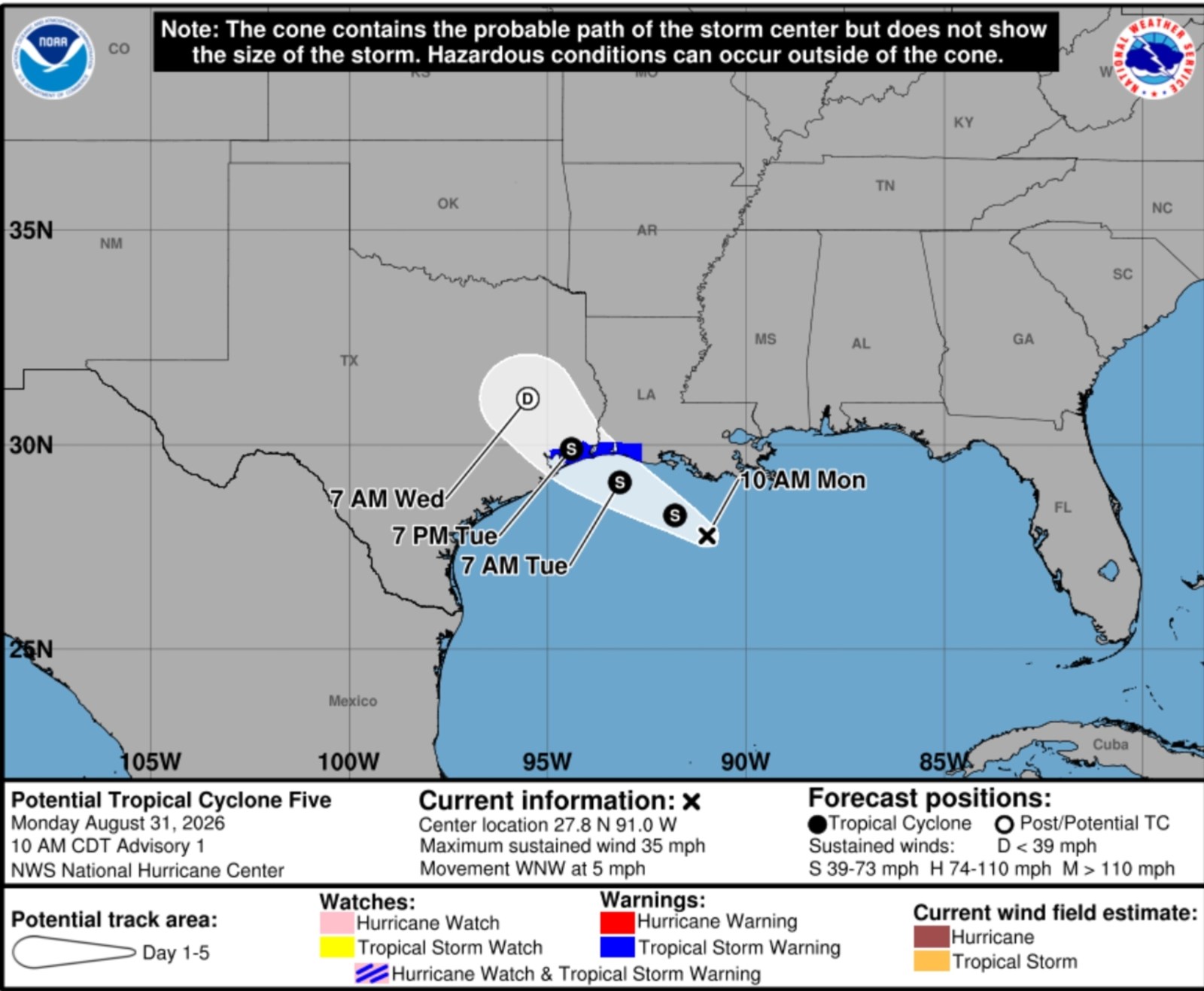
A tropical rainstorm is moving across the northern Gulf Coast, bringing heavy rain, potential flash flooding, and travel disruptions to areas of Texas and Louisiana. The main concern with this system is the heavy rainfall expected, rather than high winds. The National Hurricane Center (NHC) began issuing advisories for Potential Tropical Cyclone Five, a disturbance in the northwestern Gulf with sustained winds of 35 mph.
Tropical storm warnings have been issued for parts of the upper Texas and southwestern Louisiana coastlines as the system tracks west-northwest at approximately 5 mph. Forecasters highlight a brief window for the disturbance to strengthen before making landfall.
AccuWeather indicates that the rainstorm may develop into a tropical depression or a storm before reaching the coast on Tuesday. If it achieves tropical storm status, it would be named Edouard. Initially, the heaviest rain will impact coastal Louisiana, then spread into southeastern Texas, affecting the Houston area.
Rainfall Expectations:
The NHC projects rainfall totals of 3 to 6 inches, with isolated amounts up to 9 inches, across parts of the upper Texas coast and east-central Texas. Southwestern Louisiana might see 2 to 3 inches of rain.
Widespread rain amounts of 1 to 2 inches are anticipated along the Louisiana coast into eastern Texas, with possible higher totals from Houston to southeastern Texas. Some areas could experience up to 12 inches if thunderstorms linger. This increases the risk of road flooding and travel disruptions, particularly during peak travel times.
Weather imagery from windy.com indicates heavy rain for coastal Texas and Louisiana over upcoming days. The animated maps show areas with intense precipitation, especially on Monday evening into Tuesday for regions like Houston.
General Impacts:
- Localized areas may experience flash flooding, notably in usual trouble spots.
- Officials remind drivers to avoid flooded roads due to uncertain water depths and possible road damage beneath floodwaters.
While wind impacts are not the main threat, there could be gusty winds near the coast and hazardous sea conditions. After the system moves inland over southeastern Texas, it should weaken quickly. However, tropical moisture may persist across the Gulf Coast, keeping rain chances alive and maintaining localized flooding threats.
Leave a Reply