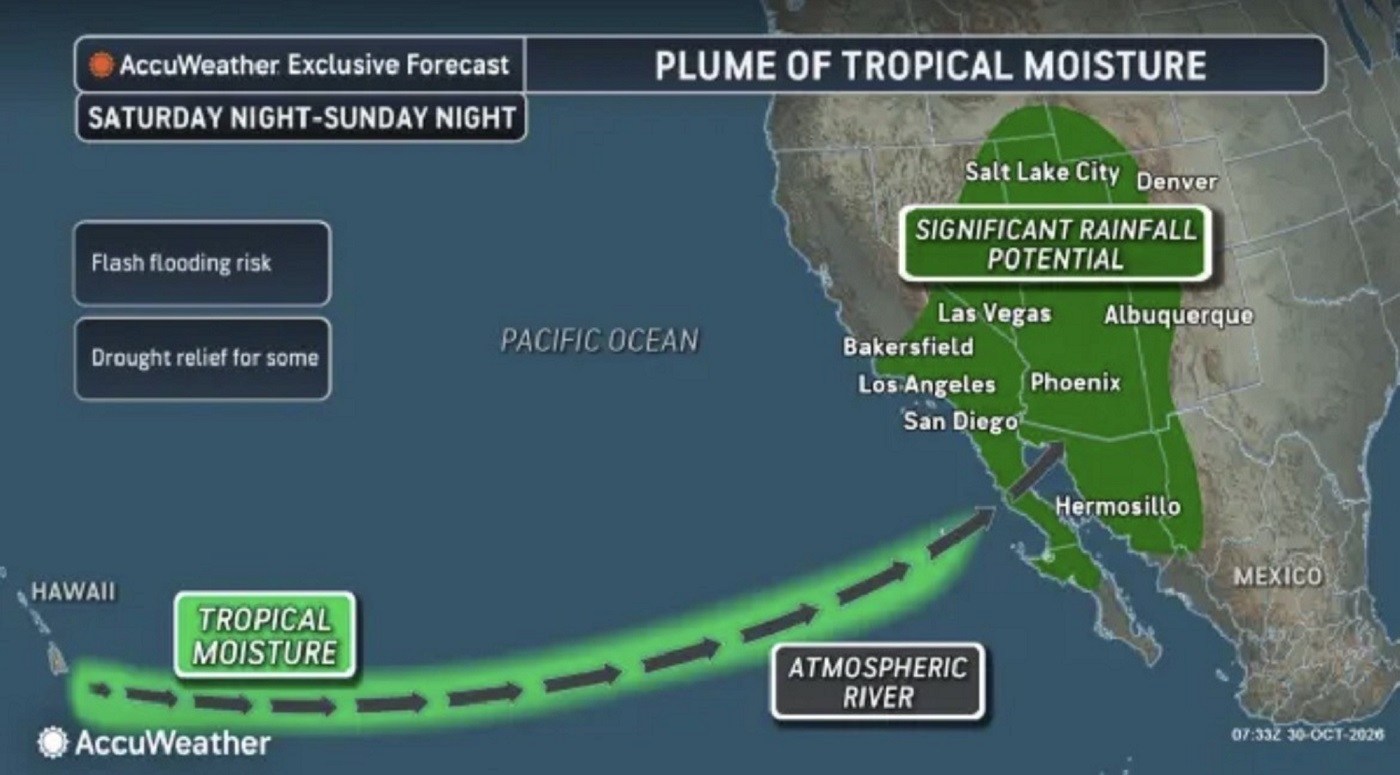
A weather map indicates a system drawing tropical moisture toward the southwestern United States, potentially bringing heavy rain, flash floods, and mountain snow over Halloween weekend. Several states may face renewed flooding risks following recent storms.
Tropical Moisture and Potential Impact
According to AccuWeather meteorologists, significant rainfall is possible in Southern California, contingent on how different storm systems combine with Pacific moisture. This could result in an atmospheric river, a concentrated water vapor corridor transporting tropical moisture to the West Coast. If the corridor extends from near Hawaii, it might evolve into a Pineapple Express.
Understanding the Pineapple Express
A Pineapple Express is a specific type of atmospheric river carrying warm, moisture-rich air from the tropical Pacific near Hawaii toward the West Coast of North America. These systems transport large volumes of water vapor, producing heavy rain and substantial snowfall, especially in mountain regions.
While they can provide much-needed rain to drought-affected areas, they pose risks when large precipitation volumes occur rapidly. Overwhelmed drainage systems and rising rivers can trigger flash floods. Mountains might see intensified snowfall, while areas with recent wildfires may be prone to mudslides.
Pineapple Express Implications
Atmospheric rivers can prolong heavy rainfall periods and cause substantial snowfall. Though beneficial for drought relief, they raise hazards due to potential rapid precipitation. Mountain regions and recent wildfire zones can experience significant threats from mudslides.
Potential Rainfall in Southern California
AccuWeather’s map illustrates possible weather system developments, highlighting areas at risk for significant rain over Halloween weekend into early next week. Two storm systems, one from Alaska and another developing off Washington’s coast, may influence this moisture influx.
The current forecast suggests these systems and their moisture will remain separate as they move along the Pacific coast. Under this scenario, Southern California’s metropolitan areas like Los Angeles, San Diego, and Palm Springs might see limited rainfall, possibly under an inch. Yet, certain mountain slopes could receive up to 3 inches.
Risks for the Southwest
The Southwest may face a notable rainfall threat, including states like Arizona, Utah, New Mexico, and Colorado. These areas are at risk for flash floods, debris flows, and rising rivers from late weekend into early next week.
Most regions could see 1 to 2 inches of rain, while some upslope areas might reach 2 to 4 inches. AccuWeather predicts local maximum rainfall of 7 inches. The concern is heightened as some areas had significant precipitation recently.
In particular, parts of the San Juan Mountains in northern New Mexico and southern Colorado saw 5 to 10 inches of rain last week, leading to record streamflows at monitoring stations. Further downpours could mean renewed flooding.
Cities like Phoenix, Flagstaff, Durango, and Farmington could experience severe weather impacts. The wider storm system also forecasts showers in the Pacific Northwest and snow in higher Rocky Mountain elevations, including parts of Montana, Idaho, Wyoming, Colorado, and Utah.
Forecasters will continue to monitor this developing pattern as more specific information on timing, tracking, and rainfall potential becomes available.
Leave a Reply