Tracking Potential Tropical Storm Isaias
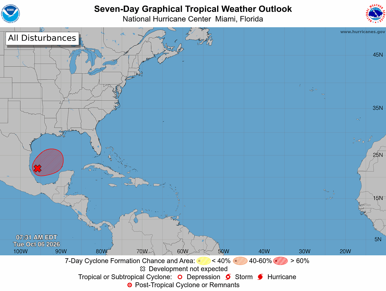
A tropical disturbance in the Gulf of Mexico is poised to develop into Tropical Storm Isaias. Forecasters are closely monitoring its trajectory toward the United States. This system could unleash flooding rains, storm surge, strong winds, and isolated tornadoes on portions of the Gulf Coast later this week. From eastern Louisiana to the Florida Panhandle, communities are urged to stay updated on forecasts. The storm is expected to approach the northern Gulf Coast by Friday or Saturday.
The National Hurricane Center is surveilling Invest 92L in the Bay of Campeche with a high probability of it developing into a tropical storm. Hurricane Hunter aircraft are dispatched to examine the disturbance as meteorologists work to gauge its speed of strengthening and ultimate landfall location.
Spaghetti Models Indicate Gulf Coast Landfall
Spaghetti model guidance suggests a concentration of tracks across the northern Gulf Coast with many indicating landfall between eastern Louisiana and the Florida Panhandle. Forecasters cite a growing consensus on this area being the probable impact zone. Meteorologist Matt Devitt pinpoints the most likely area for landfall from eastern Louisiana eastward to the Florida Panhandle. AccuWeather’s Lead Hurricane Meteorologist Alex DaSilva states the chances of the storm stalling in the Bay of Campeche are diminishing.
While forecast uncertainty prevails, AccuWeather projects high risk for areas along Mississippi’s and Alabama’s coastlines with a predicted landfall Saturday morning east of Biloxi, MS. Greater confidence in landfall timing and exact location is expected once a defined circulation forms.
The models reveal uncertainty surrounding where the storm’s center will establish and its organization speed. Nevertheless, several forecasts now focus on the U.S. Gulf Coast rather than Mexico.
Forecast Path and Landfall Expectations
The disturbance is forecasted to be steered north-northeast across the Gulf later this week. DaSilva notes that atmospheric winds likely favor a central Gulf Coast path rather than westward towards Mexico. Current projections show southeastern Louisiana, coastal Mississippi, Alabama’s shoreline, or the Florida Panhandle have the highest probability of landfall.
Forecasters warn that even minor adjustments could shift the impact zone significantly. The storm’s path will depend on circulation location, surrounding atmospheric conditions, and its strengthening rate. Intensified systems often respond differently to steering patterns compared to weaker disturbances.
Residents of the northern Gulf Coast are advised to not solely focus on forecast lines, as tropical hazards can extend far from where the storm makes landfall, especially on its eastern flank.
Potential for Tropical Storm Isaias to Become a Hurricane
Forecasters widely agree on tropical development likelihood, yet strength before landfall remains uncertain. Warm Gulf water temperatures support intensification, exceeding the usual threshold for tropical cyclone development. However, wind shear may hamper significant intensification.
DaSilva points out that while sea-surface temperatures are conducive, wind shear might restrict intensification. Nonetheless, he notes that if wind shear subsides or the storm alters course eastward, intensification conditions could improve.
AccuWeather predicts significant strengthening across the Gulf and anticipates hurricane strength by Friday; contrastingly, interactions with wind shear near the northern Gulf Coast may diminish the system before landfall.
The Hurricane Hunter aircraft are set to provide clearer insights on the storm, providing valuable data regarding its environment. Despite some scenarios hinting at a stronger cyclone, intensity forecasts carry more uncertainty than track forecasts, necessitating ongoing monitoring.
Flooding, Rain, Storm Surge, and Tornado Threats
Even if Isaias achieves hurricane strength, forecasters emphasize water hazards as major threats. Anticipated storm structure could direct heavy rainfall east of the center, increasing flash flooding and rising river risks along parts of the Gulf Coast.
AccuWeather predicts widespread rainfall totals from 1 to 4 inches with localized amounts significantly higher. Recent repeated rainfall heightens runoff problems and potential flooding.
Storm surge concerns persist along susceptible coastlines. Long-lasting onshore winds might push water inland and cause inundation in low-lying areas, even if the storm isn’t particularly intense.
Forecasters highlight flooding rainfall as the primary threat regardless of the storm’s final intensity. Heavy rain could spread into regions beyond the Gulf Coast, affecting areas as far north as Kentucky, West Virginia, then eastward toward the Carolinas.
Close to the expected landfall zone, heavier rainfall of 4-8 inches is anticipated, with AccuWeather forecasting a Local StormMax of 25 inches in southern Alabama and Mississippi.
This volume of rain risks significant flooding and hazards like mudslides in Appalachian high elevations.
Forecasts also anticipate strong winds where the storm lands; coastal communities may experience gusts of 60-80 mph, with a StormMax of 100 mph. Such winds could topple trees, power lines, and cause property damage, especially near the coast.
Tornadoes form another concern over the weekend, particularly east of the storm’s circulation center.
Outlook from the National Hurricane Center
The National Hurricane Center maintains classification of the system as Invest 92L while assessing its consolidation in the southwestern Gulf. Development chances have risen with increased thunderstorm activities surrounding the storm.
Hurricane Hunter aircraft recon missions should provide a clearer view of the storm’s structure and strength. If it develops a well-defined circulation and meets tropical-storm wind criteria, it will attain the name Isaias, becoming the ninth storm of the 2026 Atlantic hurricane season.
While monitoring by the National Hurricane Center continues, DaSilva highlights that future track and impacts depend on organization speed. Currently, the NHC lacks an established track or impact polygons.
Gulf Coast residents are encouraged to review their hurricane preparedness plans before potential watches and warnings are issued.
Preparations should include ensuring necessary supplies and understanding evacuation zones and guidance in case local emergency managers initiate evacuations.
Leave a Reply