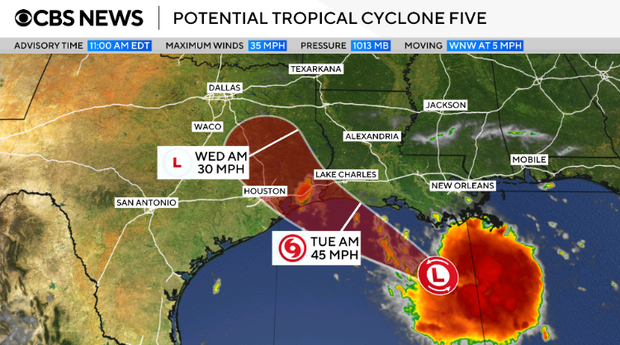
A tropical storm warning has been issued for the coastal regions of Louisiana and Texas. This follows the formation of a potential tropical cyclone in the Gulf, marking the fifth such system to develop in the 2026 Atlantic hurricane season.
The National Hurricane Center has given this system the interim title of Potential Tropical Cyclone Five. If further development occurs as expected, it will be named Tropical Storm Edouard.
Forecasted Rainfall and Impact
Forecasts suggest that the system may bring 3 to 6 inches of rain to parts of coastal Texas and certain inland areas in east-central Texas. There is a possibility of 9 inches in some areas. Southwestern Louisiana might experience 2 to 3 inches of rainfall, according to the National Hurricane Center.
Rainfall in both states poses a flash flooding risk, particularly in low-lying and urban regions. Coastal areas may also see a storm surge of up to 3 feet, raising concerns about potential flooding.
Warning Details and Expected Conditions
The current warning area stretches from Port Bolivar in Texas to the Vermilion/Cameron Parish Line in Louisiana. Tropical storm warnings indicate the likelihood of strong winds, rain, and flooding within 24 to 36 hours. The latest track suggests the storm could hit the Gulf Coast by Tuesday.
On Monday morning, the storm was moving slowly westward. Its position was about 130 miles from Morgan City, Louisiana, and 230 miles from Port Arthur, Texas. Maximum sustained winds were recorded at 35 mph as of 11 a.m. ET. This is just below the 39 mph needed for it to be officially classified as a tropical storm. However, strengthening is expected in the following day.
Leave a Reply