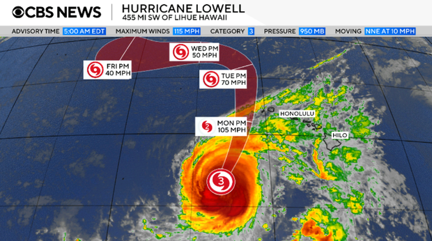
Hurricane Lowell, classified as a major Category 3 storm, is advancing toward western Hawaii. On early Monday, the hurricane brought potent winds of 115 mph. This prompted a hurricane warning for the islands of Kauai and Niihau, issued by the National Hurricane Center.
The warning extends to certain areas within the Papahanaumokuakea Marine National Monument. The monument, covering nearly 583,000 square miles and consisting of ten Hawaiian islands, lies in Lowell’s path as it skirts the island chain.
The Miami-based hurricane center forecasts that the center of Hurricane Lowell will move west of the primary Hawaiian Islands on Monday night. It is expected to decelerate by early Wednesday after moving past. Despite gradual weakening predicted through Tuesday, Lowell will likely maintain hurricane status as it nears the islands.
As of Monday, hurricane-strength winds extended up to 60 miles from the center. Expected rainfall could range between 6 to 10 inches on Kauai, with peaks hitting 14 inches in some areas. The Big Island may see 4 to 8 inches of rainfall, possibly reaching up to 12 inches in isolated spots. For Oahu, forecasts suggest 4 to 6 inches of rain, with some areas experiencing up to 8 inches.
Significant flash flooding and mudslides are anticipated, primarily in Kauai County and sections of the Big Island. A potential storm surge up to 3 feet could impact Kauai County, along with dangerous surf and rip current conditions across much of Hawaii.
The hurricane center also warned of possible tornado activity. Tornadoes could form near Kauai and Niihau from Monday afternoon through night, with limited tornado potential across the rest of Hawaii.
Leave a Reply