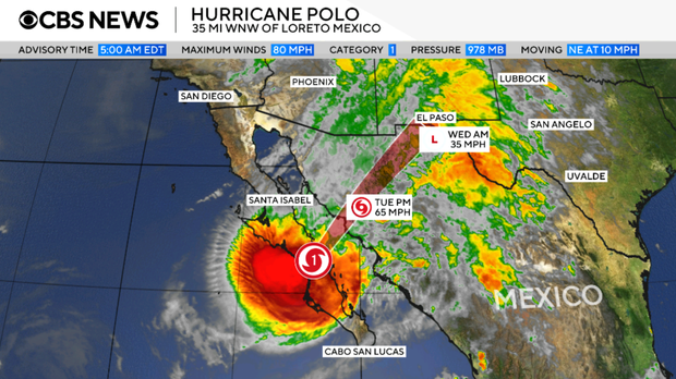
The National Hurricane Center reported that Hurricane Polo is expected to influence the southwestern United States after moving across Mexico. The powerful storm poses a risk of flash floods to over 30 million people, spanning from Arizona to Iowa. Flooding has already occurred in southern New Mexico, trapping some residents in their vehicles until water levels receded. The heavy rainfall will persist as the storm traverses the region after landfall.
Hurricane Polo’s Path
Polo is currently moving northeast at about 10 miles per hour through Mexico’s Baja California Sur. This movement will continue with a notable increase in speed. The core of the hurricane will cross the Gulf of California, making another landfall in Sonora, Mexico. Afterward, the storm will progress into the southwestern United States, reaching El Paso by Wednesday morning. By that time, it will no longer qualify as a hurricane, with wind speeds around 35 miles per hour. The storm will continue to weaken as it moves further into the Southwest.
Flash Flood Watches
Flash flood watches are active from Phoenix, Arizona to Des Moines, Iowa. This affects over 14 million Americans with potential major flooding risks. In certain areas, rainfall may accumulate to two inches per hour. The National Weather Service Prediction Center highlighted a significant flash flood threat across the Four Corners Region and into the Central Plains.
Meteorologist Rob Marciano emphasized concerns for Albuquerque, New Mexico, predicting it will receive about two inches of rain. In southern Colorado and along parts of the I-35 corridor, rain will extend into Wednesday. In Texas, including Dallas, rain could persist until Thursday, with some regions expecting more than seven inches.
Active Pacific Conditions
Hurricane Polo has shown variable intensity, fluctuating between Category 4 and Category 5. Early rapid intensification increased wind speeds by at least 58 mph within 24 hours, notably from 45 mph to 150 mph between September 21 and 22. The NHC described the change as “truly remarkable.” During the weekend, Polo’s maximum sustained winds were 180 mph. These speeds match 2009’s Hurricane Rick as the third strongest recorded in the area. Its central pressure ranks it second-strongest, trailing behind 2015’s Hurricane Patricia.
Warmer ocean waters, moist air, and reduced wind shear have contributed to increased storm formation in this region. Unusually strong El Niño conditions have also led to heightened tropical cyclone activity. Another significant storm, Hurricane Nolo, recently passed Hawaii’s Big Island, delivering heavy rain and winds over the weekend.
Leave a Reply